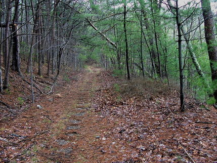
 Georgia’s Lost Highway Georgia’s Lost Highway Danny Burnham, ABG Contributor There is some prime hunting land in north Georgia known affectionately as “The Cohuttas”. My father in law introduced me to the place in 2013 on a hunting trip. I’d heard tales about the vast forest and rugged terrain from hunters, but I was blown away by how big and rugged it actually is. Between the “Wilderness” area and the Wildlife Management Area there are over 90,000 acres of hunting, fishing, camping, and hiking opportunities. Trout abound in the two rivers (Conasauga and Jacks) and deer, turkey, bear, wild hogs, and a litany of small game critters inhabit the area. Several people claim to have even encountered Bigfoot in that neck of the woods. There are over 180 miles of walking trails and another 100ish miles of dirt roads that crisscross the territory. Out of all those, I have a favorite. Georgia’s ‘Lost Highway’. Georgia Highway 2 stretches across the northern part of the state from the community of Flintstone to the South Carolina state line. It winds its way through mountains, and over rivers on its way through Walker, Cattoosa, Whitfield, Murray, Gilmer, Fannin, Union, Towns, and Rabun counties. But this piece isn’t about the 165 miles of blacktop that you can drive on today. Or even the 12 miles of dirt road that still runs through the Cohutta Wildlife Management Area. It’s about the 7 mile stretch that hasn’t been driven on in over 30 years, It is now known as East Cowpen Trail, and is every bit as “back country” as it sounds. No less than 12 miles from a paved road on either end, it’s mostly been reclaimed by nature. Which of course was the point of the 1964 Wilderness Act that started the process of designating 9.1 million acres of American woodland as “federally protected” meaning that things like roads were prohibited. The problem with that was, the road was already there. 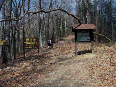 Southern Trailhead at Three Forks Mountain Trailhead Southern Trailhead at Three Forks Mountain Trailhead I suppose I should take a moment and clarify what I mean when I use words like “road” or “highway” for the purposes of this story. The “road” was never paved, and not even very well maintained. It was only ever designated a “highway” as part of a long term plan, a REALLY long term plan, to span northern Georgia with a single highway. It was basically a single vehicle in width, It took until 1975 before the reach of the Wilderness Act made its way to North Georgia and even the limited maintenance of the road ceased. From 1975-1987 it was still legal to drive on the road, but was essentially limited to off-road vehicles because of the condition of the road. Now there are only a few places left on the trail that even resemble a road, but the path has still got a lot to offer. Old Highway 2/East Cowpen Trail winds along a ridge that runs the length of Cohutta Mountain. The same ridge that divides the Cohutta Wilderness and separates the Jacks and Conasauga River Watersheds. The trail may be the flattest (ish) 7 mile stretch in the entire territory. The combination of all of those things are likely the reason they chose to build the road there to begin with. 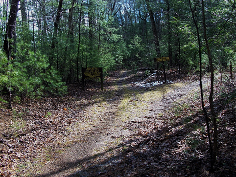 Northern Trailhead Northern Trailhead As far as hikes in the mountains go, it’s not the most rigorous. It’s easiest if you’re going from south at the Three Forks Mountain trailhead (accessed from FS64) to Forestry Service rd 51 on the north end. There are some great views, and if I had to bet my truck on the best public land spot in Georgia to see a bear, that’s where I would go. You can access Jack’s River Falls via the Rough Ridge trail which meets East Cowpen at .4 mile from the south terminus. You can also get to Panther Creek Falls on the same route. While the passage never developed into a major highway, or really a highway at all, it still gets plenty of traffic. Hikers, hunters, horseback riders all make use of East Cowpen trail. But don’t count on the local forecast. It’s said that the mountain makes its own weather. I’ve seen torrential rain. Snow, when there wasn’t snow anywhere else in Georgia. On one occasion we had to give up our hunt because the fog was so thick we couldn’t see to the end of our rifles. One thing you can count on is adventure. Just don’t feed the bears. 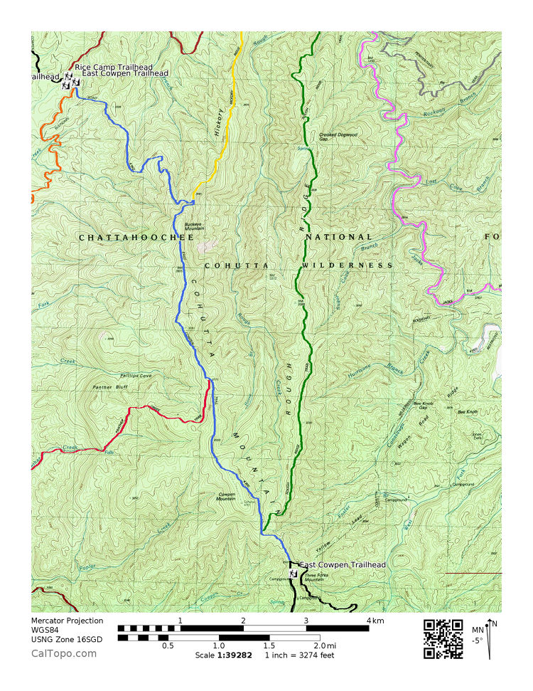 East Cowpen Trail, Georgia’s Lost Highway, Seen in Blue
1 Comment
Carey Mitchell
12/22/2023 06:23:59 pm
I traveled that section numerous times in the 70s. Leave a Reply. |

Sam B.Historian, self-proclaimed gentleman, agrarian-at-heart, & curator extraordinaire 
ABG Sponsor, Click Here
ABG Sponsor, Click Here

ABG Sponsor - Click for Link
Social Media
Categories
All
Archives
November 2022
|
 RSS Feed